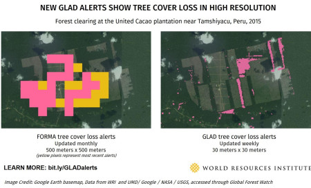
Tropical forests nearly the size of India are set to be destroyed by 2050 if current trends continue causing species loss, displacement and a major increase in climate-changing greenhouse gas emissions. Prior to the launch of the Global Land Analysis and Discovery (GLAD) alerts, researchers would have to manually track images of logging in specific areas.
The new process, developed by scientists at the University of Maryland and Google, uses an algorithm to analyze weekly updates of satellite images and sends automatic notifications about new logging activity.”This is a game changer,” said Matt Finer from the Amazon Conservation Association, an environmental group.
His organization tracks illegal logging in Peru, sending images of deforestation to policymakers, environmentalists and government officials to try and protect the Amazon rainforest. In the past, he would rely on tips from local people about encroachment by loggers, then look at older satellite images to try and corroborate the claims.
“With this new data we can focus on getting actionable information to policy makers,” Finer told the Thomson Reuters Foundation. “We have seen how powerful these images can be,” he said, citing a case where his group brought pictures of illegal gold miners cutting down trees to the Peruvian government, who then removed the miners.
Excerpt from CHRIS ARSENAULT, New satellite program aims to cut down illegal logging in real time, Reuters, Mar. 2, 2016
