The U.S. Defense Department could one day place thousands of low-cost, floating sensors into the ocean to collect environmental data, such as water temperature, as well as activity data about commercial vessels, aircraft and even fish or maritime mammals moving through the area. But others also are dropping similar sensors in the world’s oceans, and defense researchers suggest many of those systems could be integrated into an even more comprehensive ocean-based Internet of Things.
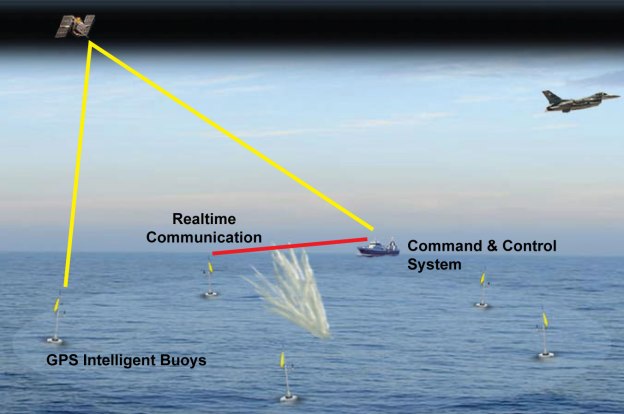
The growing Internet of Things is mostly a land-based phenomenon, frequently in large cities with loads of sensors. But researchers at the Defense Advanced Research Projects Agency (DARPA) foresee a wide range of military and civil benefits from extending the Internet of Things out to sea. The agency announced its Ocean of Things program in 2017. John Waterston, a program manager within DARPA’s Strategic Technology Office, says the sensors will float along the surface for at least one year, transmitting short messages via the Iridium satellite constellation back to a central location for analysis. “It’s a 280-byte in and 340-byte out message, so it’s a little bit more than a tweet. I like to say these things tweet about their environment,” he says.
The goal is to increase maritime awareness in a cost-effective way. Using existing systems to continuously monitor vast regions of the ocean would be cost prohibitive…. By coupling powerful analytical tools with commercial sensor technology, the agency intends to create floating sensor networks that significantly expand maritime awareness at a fraction of the cost of current approaches.
Waterston says one of the most interesting missions for the sensor might be to simply determine whether GPS signals are available in an area of interest for military operations. …The program also could help improve ocean modeling, which is important for forecasting weather, finding people who have fallen overboard or locating debris from a crashed aircraft. …The agency has yet to determine how many sensors it might eventually deploy, but they could number in the tens of thousands. To put that into perspective, DARPA officials compare the final density to placing a penny on the national mall, which Wikipedia says covers about 309 acres between the Ulysses S. Grant Memorial and the Lincoln Memorial….
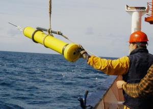
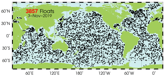
In addition, Argo, an international program, uses several thousand battery-powered, robotic floating devices to measure temperature, salinity and current for climate and oceanographic research. The floats mostly drift 10 days at a time below the ocean surface. After rising and transmitting their data to satellites, they return to depth to drift for another 10 days. The floats go as deep as 2,000 meters, according to the Argo website.
It is possible an ocean-based Internet could provide data on demand to a variety of customers inside and outside the Defense Department. If, for example, a government agency needs the water temperature in a given area reported every six hours, or a combatant command needs to know what’s happening in the Mediterranean, or NATO officials want information between Gibraltar and Sicily, or commercial fishermen need data on where the shrimp or tuna are, they could simply request it. “It’s about serving the end users. If you can use that data, we can generate it for you,” he offers. “It’s a little bit like floats-as-a-service or data-as-a-service.”
Another option is that other organizations could purchase and deploy the DARPA-developed sensors. “I hope people want to come up with their own sensors or want to buy these. I imagine a marketplace where you get many commercial people buying these. Everyone could buy 500 and then take advantage of the service provided by the thousands that are out there. I could imagine this as that foundational community,” Waterston suggests.
DARPA currently is working with three teams led by the Palo Alto Research Center, better known as PARC***, Areté Associates and Numurus LLC to develop the floats. Leidos, Draper Laboratory, SoarTech and Geometric Data Analytics are providing software for data visualization, performance prediction, float command and control and detection.
Excerpts from George Seffers, DARPA’s Ocean of Things Ripples Across Research Areas, AFCEA.org, Nov. 1, 2019
***See also DARPA’s Vanishing Programmable Resources (VAPR) program. According to one scientist that works in the PARC’s disappearing electronics platform (called DUST) “Imagine being able to cover a large area, like the ocean floor, with billions of tiny sensors to ‘hear’ what is happening within the earth’s crust, and have them quickly disintegrate into, essentially, sand, leaving no trace and not harming the planet or sea life,
