DARPA’s Space-Based Adaptive Communications Node (Space-BACN) would allow seamless communication between various constellations of satellites that currently cannot talk to each other.
“There could be tens of thousands of small satellites launched into Low Earth Orbit over the next decade as the demand around the world for affordable space-based capabilities grows,” said Greg Kuperman, Space-BACN program manager in DARPA’s Strategic Technology Office. “The problem with this growth is that optical communications links are currently engineered to only connect satellites within a given constellation – they can’t dynamically adapt waveforms to communicate with satellites in other constellations. This lack of standardization results in a fragmented, stove-piped ‘Wild West’ space domain with new satellite constellations that can’t interoperate, government satellites that can’t communicate between one another, and government satellites unable to take advantage of emerging commercial communications capabilities.”
Space-BACN envisions an adaptable communications terminal that could be reconfigured on-orbit to talk across different standards, presenting a leap in technology from the current state of the art. Space-BACN will involve inter alia a novel cross-constellation command and control approach to automate interactions between government and commercial satellites.
Space-BACN has significant military and civilian uses.
Using messenger RNA to make vaccines was an unproven idea. But if it worked, the technique would revolutionize medicine, not least by providing protection against infectious diseases and biological weapons. So in 2013 America’s Defense Advanced Research Projects Agency (DARPA) gambled. It awarded a small, new firm called Moderna $25m to develop the idea. Eight years, and more than 175m doses later, Moderna’s covid-19 vaccine sits alongside weather satellites, GPS, drones, stealth technology, voice interfaces, the personal computer and the internet on the list of innovations for which DARPA can claim at least partial credit.
It is the agency that shaped the modern world, and this success has spurred imitators. In America there are ARPAS for homeland security, intelligence and energy, as well as the original defense one…Germany has recently established two such agencies: one civilian (the Federal Agency for Disruptive Innovation, or SPRIN-d) and another military (the Cybersecurity Innovation Agency). Japan’s interpretation is called Moonshot R&D.
As governments across the rich world begin, after a four-decade lull, to spend more on research and development, the idea of an agency to invent the future (and, in so doing, generate vast industries) is alluring and, the success of DARPA suggests, no mere fantasy. In many countries there is displeasure with the web of bureaucracy that entangles funding systems, and hope that the DARPA model can provide a way of getting around it. But as some have discovered, and others soon will, copying DARPA requires more than just copying the name. It also needs commitment to the principles which made the original agency so successful—principles that are often uncomfortable for politicians.
On paper, the approach is straightforward. Take enormous, reckless gambles on things so beneficial that only a handful need work to make the whole venture a success. As Arun Majumdar, founding director of ARPA-e, America’s energy agency, puts it: “If every project is succeeding, you’re not trying hard enough.” Current (unclassified) DAROA projects include mimicking insects’ nervous systems in order to reduce the computation required for artificial intelligence and working out how to protect soldiers from the enemy’s use of genome-editing technologies.
The result is a mirror image of normal R&D agencies. Whereas most focus on basic research, DARPA builds things. Whereas most use peer review and carefully selected measurements of progress, DARPA strips bureaucracy to the bones (the conversation in 1965 which led the agency to give out $1m for the first cross-country computer network, a forerunner to the internet, took just 15 minutes). All work is contracted out. DARPA has a boss, a small number of office directors and fewer than 100 program managers, hired on fixed short-term contracts, who act in a manner akin to venture capitalists, albeit with the aim of generating specific outcomes rather than private returns.
Excerpt from Inventing the future: A growing number of governments hope to clone America’s DARPA, Economist, June 5, 2021
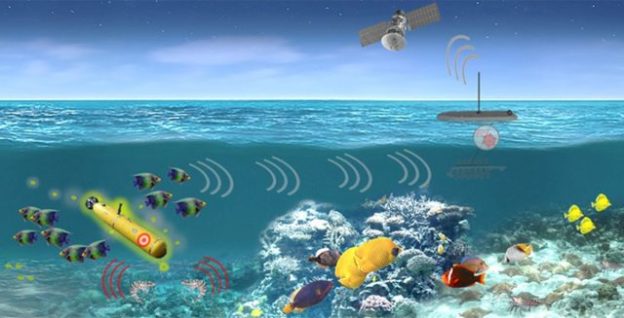
The U.S. Defense Department could one day place thousands of low-cost, floating sensors into the ocean to collect environmental data, such as water temperature, as well as activity data about commercial vessels, aircraft and even fish or maritime mammals moving through the area. But others also are dropping similar sensors in the world’s oceans, and defense researchers suggest many of those systems could be integrated into an even more comprehensive ocean-based Internet of Things.
The growing Internet of Things is mostly a land-based phenomenon, frequently in large cities with loads of sensors. But researchers at the Defense Advanced Research Projects Agency (DARPA) foresee a wide range of military and civil benefits from extending the Internet of Things out to sea. The agency announced its Ocean of Things program in 2017. John Waterston, a program manager within DARPA’s Strategic Technology Office, says the sensors will float along the surface for at least one year, transmitting short messages via the Iridium satellite constellation back to a central location for analysis. “It’s a 280-byte in and 340-byte out message, so it’s a little bit more than a tweet. I like to say these things tweet about their environment,” he says.
The goal is to increase maritime awareness in a cost-effective way. Using existing systems to continuously monitor vast regions of the ocean would be cost prohibitive…. By coupling powerful analytical tools with commercial sensor technology, the agency intends to create floating sensor networks that significantly expand maritime awareness at a fraction of the cost of current approaches.
Waterston says one of the most interesting missions for the sensor might be to simply determine whether GPS signals are available in an area of interest for military operations. …The program also could help improve ocean modeling, which is important for forecasting weather, finding people who have fallen overboard or locating debris from a crashed aircraft. …The agency has yet to determine how many sensors it might eventually deploy, but they could number in the tens of thousands. To put that into perspective, DARPA officials compare the final density to placing a penny on the national mall, which Wikipedia says covers about 309 acres between the Ulysses S. Grant Memorial and the Lincoln Memorial….
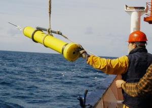
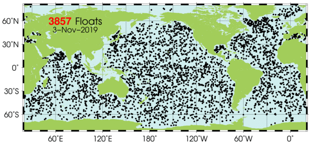
In addition,Argo, an international program, uses several thousand battery-powered, robotic floating devices to measure temperature, salinity and current for climate and oceanographic research. The floats mostly drift 10 days at a time below the ocean surface. After rising and transmitting their data to satellites, they return to depth to drift for another 10 days. The floats go as deep as 2,000 meters, according to the Argo website.
Argo Floating Device
It is possible an ocean-based Internet could provide data on demand to a variety of customers inside and outside the Defense Department. If, for example, a government agency needs the water temperature in a given area reported every six hours, or a combatant command needs to know what’s happening in the Mediterranean, or NATO officials want information between Gibraltar and Sicily, or commercial fishermen need data on where the shrimp or tuna are, they could simply request it. “It’s about serving the end users. If you can use that data, we can generate it for you,” he offers. “It’s a little bit like floats-as-a-service or data-as-a-service.”
Argo’s Ocean Sensors
Another option is that other organizations could purchase and deploy the DARPA-developed sensors. “I hope people want to come up with their own sensors or want to buy these. I imagine a marketplace where you get many commercial people buying these. Everyone could buy 500 and then take advantage of the service provided by the thousands that are out there. I could imagine this as that foundational community,” Waterston suggests.
DARPA currently is working with three teams led by the Palo Alto Research Center, better known as PARC***, Areté Associates and Numurus LLC to develop the floats. Leidos, Draper Laboratory, SoarTech and Geometric Data Analytics are providing software for data visualization, performance prediction, float command and control and detection.
Excerpts from George Seffers, DARPA’s Ocean of Things Ripples Across Research Areas, AFCEA.org, Nov. 1, 2019
***See also DARPA’s Vanishing Programmable Resources (VAPR) program. According to one scientist that works in the PARC’s disappearing electronics platform (called DUST) “Imagine being able to cover a large area, like the ocean floor, with billions of tiny sensors to ‘hear’ what is happening within the earth’s crust, and have them quickly disintegrate into, essentially, sand, leaving no trace and not harming the planet or sea life,
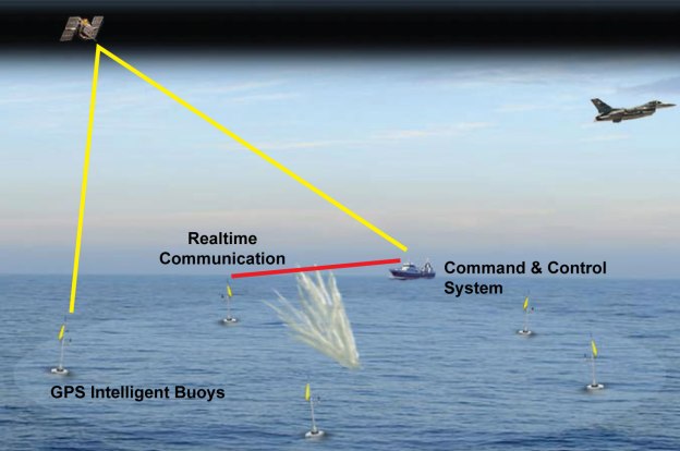
The objective of the POSYDON program is to develop an undersea system that provides omnipresent, robust positioning. DARPA envisions that the POSYDON program will distribute a small number of acoustic sources, analogous to GPS satellites, around an ocean basin. By measuring the absolute range to multiple source signals, an undersea platform can obtain continuous, accurate positioning without surfacing for a GPS fix.
Teaming up with Northrop Grumman as its primary contractor, DARPA is working today to integrate micro-electro-mechanical systems, called MEMS, and atomic inertial guidance technologies, forming a new “single inertial measurement unit” in a project designated the “Chip-Scale Combinatorial Atomic Navigator” — C-SCAN.
Translated into plain English, what C-SCAN aims to accomplish is to create a chip that performs the functions today served by orbiting GPS satellites. The chip would constantly “know” where it is in space-time, and would have this knowledge without having to ping a satellite (and maintain line-of-sight communication with a satellite) to do it… Elimination of the need to rely on satellites to determine one’s location would similarly enable the use of “GPS-like” technology for getting directions within buildings and underground — for example, in subway systems…
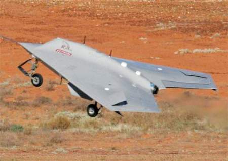
One of the primary vulnerabilities in today’s hi-tech, ultra-accurate weapons systems, you see, is their dependence upon GPS signals to guide them to their destinations. American “smart bombs” and guided missiles all depend greatly on GPS to know where they are, and to get where they’re going. American dominance in drone technology, similarly, depends on GPS. Problem is, while we know this is a problem, the “bad guys” know it, too — and can sometimes hack GPS signals so as to confuse, and even hijack, American weapons systems. Case in point: in 2011, Iran boasted that it had commandeered and captured a Lockheed Martin RQ-170 Sentinel — one of our most advanced “stealth” surveillance drones — in flight over Iranian territory. The Iranians didn’t have to shoot the drone down, either. Instead, they forced it to land in Iran, and captured it intact. According to Iranian engineers, this was accomplished by first jamming communications with the Sentinel’s remote controllers, then “spoofing” GPS signals, tricking the drone into landing at what it thought was its home base in Afghanistan — but what was actually an Iranian airfield.
Drones equipped with a future C-SCAN technology would be less likely to fall victim to such a trap. While their communications might be cut off, forcing them to default to autopilot and return to base, they’d at least return to the right base, because an internal chip would tell them how to get there.
Current weapons systems often include internal gyroscopes, granted, that perform some of the functions that C-SCAN aims to perfect. But as DARPA observes, present-day gyroscopes are “bulky” equipment, “expensive,” and don’t perform with the kind of accuracy that DARPA wants to see. The objective, therefore, is to explore cutting edge technologies to put gyroscope-like functionality on a chip, resulting in “small size, low power consumption, high resolution of motion detection and a fast start up time” — all loaded onto one small microchip….
Microchip-based guidance could be the solution the military is seeking to an oft-discussed problem with the nation’s newest generation of Mach 7 railguns, whose great range, speed, power — and cheapness — make them an attractive weapons system… if we can only figure a way to guide their projectiles accurately
Rich Smith, Why Is the U.S. Government Working Frantically to Get Rid of GPS?, Motley Fool, June 15, 2015
GPS jammers are cheap: a driver can buy a dashboard model for about £50 ($78). They are a growing menace. The bubbles of electromagnetic noise they create interfere with legitimate GPS users. They can disrupt civil aviation and kill mobile-phone signals, too. In America their sale and use is banned. In Britain they are illegal for civilians to use deliberately, but not, yet, to buy: Ofcom, a regulator, is mulling a ban. In recent years Australian officials have destroyed hundreds of jammers.
In the right (or wrong) hands, they are potential weapons. Britain’s armed services test the devices in the Brecon Beacons in Wales, a military training area. North Korea uses big lorry-mounted versions to block GPS signals in South Korea. Starting with a four-day burst in August 2010, the attacks, which come from three positions inside the North, have lengthened. In early 2012 they ran for 16 days, causing 1,016 aircraft and 254 ships to report disruption…Criminals or terrorists could knock out GPS for an entire city or shipping lane anywhere in a flash. Even without North Korean-sized contraptions, the jamming can be substantial. Suitcase-sized devices on sale on the internet claim a range of 300-1,000 metres.
Malfunctioning satellites and natural interference from solar activity have hit GPS signals and sent ships off course. David Last, a navigation expert, says an accidental power cut, perhaps caused by a jammer taken on board a car ferry, could cause a shipwreck. Generating a false signal—spoofing—is another threat. In December 2011 Iran said it had spoofed an American drone before capturing it (most experts dismiss the claim). So far effective spoofing seems confined to laboratories, but Mr Last says some governments are already taking countermeasures.
One solution is a different means of navigation. In April South Korea announced plans for a network of 43 eLoran (enhanced long-range navigation) ground-based radio towers, based on technology first used in the second world war. It uses a far stronger signal than GPS, and should give pilots and ships’ captains a safer alternative by 2016. With Chinese and Russian help, South Korea hopes to expand coverage across the region. Britain’s General Lighthouse Authorities (GLA) are following suit with seven new eLoran stations. Martin Bransby, an engineer with the GLA, says this will replace visual navigation as the main backup for GPS. It will be working by mid-2014, and cost less than £700,000; receivers cost £2,000 per vessel. By 2019 coverage should reach all big British ports.
America’s military-research agency DARPA has an experimental “single-chip timing and inertial measurement unit” (TIMU). When finished, according to the project’s boss, Andrei Shkel, it will use tiny gyroscopes and accelerometers to track its position without using satellites or radio towers. America’s White Sands missile range in New Mexico is installing a “Non-GPS Based Positioning System”, using ground-based antennae to provide centimetre-level positioning over 2,500 square miles. In May the Canadian government said it would splash out on anti-jam upgrades for military aircraft.
A new version of the US air force’s bunker-busting bomb, designed in part to destroy Iranian nuclear facilities, includes technology to prevent defenders from blocking its satellite-based guidance systems. MBDA, a European missile firm, is working on similar lines.
But for many users, GPS and other space-based navigation systems—which include Russia’s GLONASS, China’s partly complete Beidou, and an as-yet unfinished project by the European Union—remain indispensable and ubiquitous. They are also vulnerable. For those whose lives or livelihoods depend on knowing where they are, more resilient substitutes cannot come fast enough.
GPS jamming: Out of sight, Economist, July 27, 2013, at 51
DARPA’s All Source Positioning and Navigation (ASPN) program seeks to enable low cost, robust, and seamless navigation solutions for military users on any operational platform and in any environment, with or without GPS. In particular, ASPN will develop the architectures, abstraction methods, and navigation filtering algorithms needed for rapid integration and reconfiguration of any combination of sensors. This will enable rapid adaptation to evolving missions as well as reduction of the system integration costs and time-to-market for navigation solutions in general.
The goal of Phase 2 of ASPEN is to address the issues of optimization and real-time operation, showing capabilities beyond basic plug-and-play flexibility. Solutions must be capable of adapting to a diverse set of sensor and IMU inputs and selectively choosing the subset of measurements that produces the best possible solution, ideally mirroring the result from a tuned filter solution for that same scenario….Phase 2 solutions will need to demonstrate real-time operation in representative field (non-laboratory) environments. Although adaptability is the main goal of the ASPN program, the possibility of ASPN accuracy being substantially better than current state of art should be considered, given accommodation by ASPN of larger and more diverse sensor suites, ease of optimizing ASPN to immediate applications, and potential synergistic benefits of an open architecture.