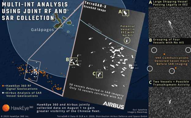
In the middle of last year, Ecuadorians watched with concern as 340 foreign boats, most of them Chinese, fished just outside the Exclusive Economic Zone (EEZ) around their country’s westernmost province, the Galapagos Islands. The law of the sea requires such vessels to carry GPS-based automatic identification systems (AIS) that broadcast where they are, and to keep those systems switched on. Some boats, however, failed to comply. There were more than 550 instances of vessels not transmitting their locations for over a day. This regular radio silence stoked fears that the boats concerned were sneaking into Ecuador’s waters to plunder its fish.
Both local officials and China’s ambassador to Ecuador denied this, and said all the boats were sticking to the rules. In October 2020, however, HawkEye 360, a satellite operator based in Virginia, announced it had detected vessels inside Ecuador’s EEZ on 14 occasions when the boats in question were not transmitting AIS. HawkEye’s satellites could pinpoint these renegades by listening for faint signals emanating from their navigation radars and radio communications.
HawkEye’s satellites are so-called smallsats, about the size of a large microwave oven. They are therefore cheap to build and launch. HawkEye deployed its first cluster, of three of them, in 2018. They are now in an orbit that takes them over both of Earth’s poles. This means that, as the planet revolves beneath them, every point on its surface can be monitored at regular intervals…Unlike spy satellites fitted with optical cameras, RF satellites can see through clouds. Their receivers are not sensitive enough to detect standard mobile phones. But they can pick up satellite phones, walkie-talkies and all manner of radar. And, while vessels can and do illicitly disable their AIS, switching off their communications gear and the radar they use for navigation and collision-avoidance is another matter entirely. “Even pirates don’t turn those things off,” says John Beckner, boss of Horizon Technologies….
RF data are also cheap to collect. Satellites fitted with robotic high-resolution cameras are costly. Flying microwave ovens that capture and timestamp radio signals are not. America’s National Geospatial-Intelligence Agency (NGA), one of that country’s numerous spying operations, is a big user of RF intelligence. It employs HawkEye’s data to find guerrilla camps and mobile missile-launchers, and to track both conventional warships and unconventional ones, like the weaponised speedboats sometimes deployed by Iran. Robert Cardillo, a former director of the agency who now advises HawkEye, says dozens of navies, Russia’s included, spoof AIS signals to make warships appear to be in places which they are not. RF intelligence is not fooled by this. Mr Cardillo says, too, that the tininess of RF satellites makes them hard for an enemy to destroy.
Beside matters military, the NGA also uses RFdata to unearth illicit economic activity—of which unauthorised fishing is merely one instance. Outright piracy is another. And the technique also works on land. In 2019, for example, it led to the discovery of an illegal gold mine being run by a Chinese company in a jungle in Gabon. And in 2020 the managers of Garamba National Park in the Democratic Republic of Congo began using HawkEye data to spot elephant poachers and dispatch rangers to deal with them…
Horizon also plans to compile a library of unique radar-pulse “fingerprints” of the world’s vessels, for the tiny differences in componentry that exist even between examples of the same make and model of equipment mean that signals can often be linked to a specific device. It will thus be able to determine not merely that a vessel of some sort is in a certain place, but which vessel it is, and where else it has been…
Excerpt from Espionage: Ears in the Sky, Economist, Mar. 20, 2021
