Tag Archives: satellite tracking

Space Control in the Future of War: Ukraine

The Starlink constellation of SpaceX currently consists of 3,335 active satellites and has become an integral part of Ukraine’s military and civil response to Russia’s invasion…Appropriately enough, the story started with a tweet, one sent by Mykhailo Fedorov, Ukraine’s minister of digital transformation, two days after the invasion:

@elonmusk, while you try to colonize Mars —Russia try to occupy Ukraine! While your rockets successfully land from space—Russian rockets attack Ukrainian civil people! We ask you to provide Ukraine with Starlink stations and to address sane Russians to stand.

Mr Musk replied to him within hours, saying that the Starlink service had been turned on over Ukraine and that the hardware would follow. Within days lorries full of the pizza-sized flat dishes used to access the satellites began to arrive in Ukraine.

By May 2022 around 150,000 people were using the system every day. The government quickly grew to rely on it for various communication needs, including, on occasion, the transmission of the nightly broadcast by Volodymyr Zelensky, Ukraine’s president. Because the dishes and their associated terminals are easily portable and can be rigged to run off a car battery, they are ideal for use in a country where the electricity and communication networks are regularly pounded by Russian missiles. When Kherson was liberated in November 2022 Starlink allowed phone and internet services to resume within days.

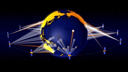
Crucially, Starlink has become the linchpin of what military types call C4ISR (command, control, communications, computers, intelligence, surveillance and reconnaissance). Armies have long relied on satellite links for such things…But Most satellite communications make use of big satellites which orbit up at 36,000km. Perched at such a height a satellite seems to sit still in the sky, and that vantage allows it to serve users spread across very large areas. But even if such a satellite is big, the amount of bandwidth it can allocate to each user is often quite limited.

The orbits used by Starlink’s much smaller satellites are far lower: around 550km. This means that the time between a given satellite rising above the horizon and setting again is just minutes. To make sure coverage is continuous thus requires a great many satellites, which is a hassle. But because each satellite is serving only a small area the bandwidth per user can be high. And the system’s latency—the time taken for signals to get up to a satellite and back down to Earth—is much lower than for high-flying satellites. 

Franz-Stefan Gady, of the International Institute for Strategic Studies, a think-tank, recently visited the Ukrainian front lines and saw an example of what cheap, ubiquitous connectivity makes possible: a sort of Uber for howitzers. .. “Ukrainian military operations are hugely dependent on having access to the internet,” says Mr Gady, “so Starlink is a most critical capability.” A Ukrainian soldier puts it more starkly. “Starlink is our oxygen,” he says. Were it to disappear “Our army would collapse into chaos.”…

Starlink signals are strong compared with those from higher flying satellites, which makes jamming them harder. And the way that the dishes use sophisticated electronics to create narrow, tightly focused beams that follow satellites through the sky like invisible searchlights provides further resistance to interference…

If its signals cannot be jammed, the system itself could be attacked instead….Cyber-attacks like the one aimed at Ukraine’s legacy satellite system on February 24, 2022 are one possibility. So far, though, similar sallies against Starlink appear to have been ineffective, in part thanks to SpaceX’s ability to quickly update the system’s software. Dave Tremper, director of electronic warfare for the Office of the Secretary of Defense, has said the speed of the software response he witnessed to one attack was “eye-watering”.

And then there are the satellites themselves. America, China, India and Russia have missiles that can shoot satellites out of the sky. Again, though, using them would seem a severe escalation. It would also be a lot less useful against a constellation like Starlink than against older systems. Knocking out a single Starlink would achieve more or less nothing. If you want to damage the space-based bit of the system, you need to get rid of lots of them…

In 2020 China filed documents with the International Telecommunication Union, a UN body, for a 13,000-satellite constellation of its own.

Excerpts from The Satellites that Saved Ukraine, Economist, Jan. 7, 2023

Stargazing as a Right and Colonization of Skies

Do people have a right to an unobstructed view of the heavens? For most of human history, such a question would have been considered nonsensical—but with the recent rise of satellite mega constellations, it’s now being asked again and again. Mega constellations are vast groups of spacecraft, numbering in the thousands, that could spark a multitrillion-dollar orbital industry and transform global connectivity and commerce. But the rise of mega constellations also threatens to clutter the night sky, disrupt the work of some astronomers and create space debris that harms people on Earth and in space alike. The mega constellation era began in May 2019, when Elon Musk’s firm SpaceX launched the first 60 satellites in its Starlink constellation… Today the constellation’s numbers have swelled to more than 3,000 and account for fully half of all active satellites in space.

Ramon Ryan has argued in the in the Vanderbilt Journal of Entertainment and Technology Law that the regulatory approval of these satellites by the U.S. Federal Communications Commission (FCC) may breach environmental law as part of the U.S. National Environmental Policy Act (NEPA) enacted in 1970. Specifically, he argued that the natural aesthetic of the night sky and the profession of astronomy may be protected under NEPA—but that the FCC has so far sidestepped NEPA’s oversight , thanks to a “categorical exclusion” the agency was granted in 1986 (when it simply wasn’t licensing that many satellites)….  

In November 2022, the US General Accounting Office (GAO) published a report that suggest that the FCC should revisit its categorical exclusion from NEPA and consider whether it should update its procedures in light of the rise of mega constellations. “We think they need to revisit [the categorical exclusion] because the situation is so different than it was in 1986,” says Andrew Von Ah, a director at the GAO…The White House Council on Environmental Quality (CEQ) recommends that agencies “revisit things like categorical exclusions once every seven years,” Von Ah says. But the FCC “hasn’t really done that since 1986.”

According to the report’s recommendations, the FCC should review whether mega constellations affect the environment…The findings showed there were concerns in a number of areas, not just the brightness of the satellites but also the collision risk they pose in space and the possible creation of space junk, the interference to radio astronomy caused by satellite radio transmissions and even the potential for satellites reentering the atmosphere to affect Earth’s climate or harm humans on the ground. ..

The day after the GAO report’s release, the FCC  announced the creation of a new bureau for its space activities, which will help the agency handle the applications for 64,000 new satellites it is presently considering…

Excerpts from  Jonathan O’Callaghan Satellite Constellations Could Harm the Environment, New Watchdog Report Says, Scientific American, November 24, 2022

How Come Space is Full of Human Junk?

Getting rid of the deadly debris orbiting the Earth should become a priority for firms trying to do business there. If only they knew exactly where it is. The space race comes with a growing litter problem: U.S. officials expect the number of satellites to increase almost tenfold to 58,000 by 2030, many of them with lifespans not much longer than five years.

Space trash could potentially trigger devastating chain reactions, posing a significant threat to a space economy that is forecast by Morgan Stanley to generate $1 trillion in revenues by 2040. Only three big collisions have happened to date, but close calls are increasingly common. In November 2021, denizens of the International Space Station (ISS) had to take refuge in their capsules after a Russian antisatellite missile test created a cloud of wreckage.

In September 2022, the U.S. Federal Communications Commission ruled that operators of satellites in the “low Earth orbit,” or LEO—below 1,200 miles of altitude—will, in two years’ time, be required to remove them “as soon as practicable, and no more than five years following the end of their mission.” The National Aeronautics and Space Administration, or NASA, did ask for space junk to be disposed of within 25 years, but these were voluntary guidelines. NASA said in a 2021 report that compliance has averaged under 30% over the past decade. Yet 90% compliance would be required just to slow the pace at which dead satellites, rocket bodies and loose fragments are accumulating. There may be little choice but to mount a cleanup operation. The main questions are who will do it and how the junk will be found.

With only limited interest from big aerospace companies, startups have stepped up. Months after its inception in 2018, Switzerland’s ClearSpace signed a €86.2 million ($86.3 million) contract with the European Space Agency, or ESA, to eliminate remains of a Vega rocket by 2025. ClearSpace will use a robot to get hold of the debris and burn it in the atmosphere. Then there is Tokyo-based Astroscale, which has raised $300 million in venture capital since its inception nine years ago. This September, the U.K. Space Agency awarded £4 million, equivalent to $4.6 million, to both companies to remove defunct British satellites by 2026.

The LEO revolution unleashed by Elon Musk’s SpaceX, which has launched over 3,000 of its miniaturized Starlink satellites, may suddenly turn this into a viable commercial market. Officials are getting spooked by all the extra clutter. In orbits lower than 375 miles, re-entry into the Earth naturally happens after a few years, but these will be crowded by Starlink alone. Many players will need to go higher, and set up “deorbit” plans that regulators—and sustainability-minded investors—find solid.

That still leaves satellite operators and trash-removal firms with a fundamental problem: Their information on an object, including position, shape and mass, involves a lot of guesswork. Most observations come from ground radars, which firms access through government agencies like the U.S. Space Command. But this data is often several hours old and can miss the mark by miles, so satellites and stations can’t swerve out of the way of approaching debris with full confidence. For removal missions, this will mean accommodating extra fuel and allowing for the possibility that an object is spinning faster than estimated, making it impossible to grab.

And this is for pieces larger than 10 centimeters, which according to the ESA number above 30,000 and are the only ones visible from Earth. Mathematical models suggest there are a million additional fragments measuring between one and 10 centimeters, and 100 million even smaller than that, often traveling many times faster than a bullet. Yet the ISS’s “Whipple shield” can be pierced by anything larger than one centimeter…

[A]ny company aspiring to profit from the final frontier will need to better understand the risks of the terrain. The alternative is a true tragedy of the commons that ends a promising new space age before it has really begun.

Excerpts from Jon Sindreu, The Difficult Search for Dangerous Space Junk, WSJ, Nov. 14, 2022

Toxic Waste: Down the Toilet and into the Seas

Dumping oily wastewater into the ocean has been outlawed globally for decades, but an investigation by DW, in collaboration with the European nonprofit newsroom Lighthouse Reports and eight other European press outlets, has found that the practice is still common today, with potentially devastating effects for the environment.

Satellite imagery and data provided by the environmental group SkyTruth helped identify hundreds of potential dumps across the globe in 2021 alone. But the number of spills is most likely significantly higher because the satellites used by SkyTruth cover less than one-fifth of the world’s oceans. According to the group’s estimate, the amount of oily water dumped into the oceans this way could amount to more than 200,000 cubic meters (52.8 million gallons) annually, or roughly five times the equivalent of the 1989 Exxon Valdez spill in Alaska — one of the worst maritime environmental disasters.

As merchant ships make their journeys, liquids from the engine room, oil, detergents, water and other substances collect in the bottom of the vessel, the bilge. This noxious mixture, called “bilgewater,” is then stored in tanks. In a day, a single merchant ship can produce several tons of it. International regulations require that large vessels treat the bilgewater with an “oily water separator” before it is discharged into the ocean. Each liter of bilgewater pumped into the sea after treatment is permitted a maximum residual-oil proportion of 15 parts per million, or 15 milligrams of oil per liter of water (0.0005 ounces per quart), according to a limit set by the International Maritime Organization (IMO) in 1973. The remaining toxic mixture is stored in tanks onboard and later discharged at harbor in port reception facilities.

All big vessels are required to have working separators. But many ships circumvent the system entirely…through a small, portable pump. “It’s very easy,” one man who had witnessed it in operation on several occasions told DW. “You can assemble this portable pump in five minutes and then detach (in) five minutes and hide (it) if someone is coming.”

The pump is used to transfer the oily water into a different tank — in most cases, the sewage tank. On the high seas, ships are allowed to dump their sewage untreated. Then, the toxic mix is quietly released into the ocean, often under the cover of night or during inclement weather, when there is a lower chance of getting caught, according to several seafarers DW talked to. At night it is harder for authorities to verify the crime, and bad weather can prevent the deployment of surveillance ships and planes… Because the illegal dumps happen at sea, it is difficult for authorities and researchers to track them. That is why satellite imagery is used to monitor the seas for pollution. When a vessel discharges oily wastewater illegally, it usually creates a spill kilometers long and with a very distinct shape.

A system set up in 2007 by the European Maritime Safety Agency, or EMSA, uses radar satellites to “see” through cloud cover and at night to identify possible spills. It alerts the respective member states when one is found…Illegal dumps “still regularly occur in European waters,” according to EMSA, and the number of spills detected and prosecuted remains low. Individual member states do not always follow up on the alerts, and, when they do, it is often not quickly enough. The longer it takes authorities to verify a spill in situ, the less likely they are to find oil, as spills begin to dissipate. In 2019, only 1.5% of spills were verified within a critical three-hour time frame. Polluters are only caught in a fraction of cases.

The satellites are also not able to monitor EU waters continuously, meaning that there is a window of several hours each day during which oil spills can go unnoticed. To get a sense of the total scope of this issue in EU waters, SkyTruth combined data and assumptions from EMSA with calculations of satellite coverage. Based on that fairly conservative estimate, the group expects that every year nearly 3,000 slicks are caused by vessels discharging mineral oil into EU waters. That averages out to more than eight per day — the majority of which go unseen by satellites.

Excerpts from Exclusive: How chronic oil pollution at sea goes unpunished, DW, Mar. 2022

The Right to Know from Space

Rebuilding an entire planet’s energy system is a big job…The most basic problem is knowing what, exactly, you are trying to rebuild. Academic-research groups, think-tanks, charities and other concerned organizations try to keep track of the world’s wind turbines, solar-power plants, fossil-fueled power stations, cement factories and so on. To this end, they rely heavily on data from national governments and big companies, but these are often incomplete. The most comprehensive database covering American solar-power installations, for instance, is thought to miss around a fifth of the photovoltaic panels actually installed on the ground.

In a paper published in Nature, a team of researchers demonstrate another way to keep tabs on the green-energy revolution. Dr Kruitwagen and his colleagues have put together an inventory of almost 69,000 big solar-power stations (defined as those with a rated capacity of 10kw of electricity or more) all over the world—more than four times as many as were previously listed in public databases. This new inventory includes their locations, the date they entered service and a rough estimate of their generating capacity…

Pictures came from two sets of satellites, Sentinel-2 and SPOT, run by the European Space Agency and Airbus respectively. These peer down on the world, recording visible light and also the infrared and ultraviolet parts of the spectrum. The images amounted to around 550 terabytes of data, spanning the period between 2016 and 2018. That is enough to fill more than a hundred desktop hard drives. Sifting through this many pictures by eye would have been impractical. That is where the second technological trend comes in. Dr Kruitwagen and his colleagues trained a machine-learning system to spot the solar panels for them.

More generally, Dr Kruitwagen hopes that his eye-in-the-sky approach—which, despite the planetary scale of the project, cost only around $15,000 in cloud-computing time—could presage more accurate estimates of other bits of climate-related infrastructure, such as fossil-fuel power stations, cement plants and terminals for ships carrying liquefied natural gas. The eventual result could be the assembly of a publicly available, computer-generated inventory of every significant bit of energy infrastructure on Earth. Quite apart from such a model’s commercial and academic value, he says, an informed public would be one better able to hold politicians’ feet to the fire. 

Excerpt from Solar-cell census: An accurate tally of the world’s solar-power stations, Economist, Oct. 30, 2021

Hearing the Naked Truth: Earth Observation

In the middle of last year, Ecuadorians watched with concern as 340 foreign boats, most of them Chinese, fished just outside the Exclusive Economic Zone (EEZ) around their country’s westernmost province, the Galapagos Islands. The law of the sea requires such vessels to carry GPS-based automatic identification systems (AIS) that broadcast where they are, and to keep those systems switched on. Some boats, however, failed to comply. There were more than 550 instances of vessels not transmitting their locations for over a day. This regular radio silence stoked fears that the boats concerned were sneaking into Ecuador’s waters to plunder its fish.

Both local officials and China’s ambassador to Ecuador denied this, and said all the boats were sticking to the rules. In October 2020, however, HawkEye 360, a satellite operator based in Virginia, announced it had detected vessels inside Ecuador’s EEZ on 14 occasions when the boats in question were not transmitting AIS. HawkEye’s satellites could pinpoint these renegades by listening for faint signals emanating from their navigation radars and radio communications.

HawkEye’s satellites are so-called smallsats, about the size of a large microwave oven. They are therefore cheap to build and launch. HawkEye deployed its first cluster, of three of them, in 2018. They are now in an orbit that takes them over both of Earth’s poles. This means that, as the planet revolves beneath them, every point on its surface can be monitored at regular intervals…Unlike spy satellites fitted with optical cameras, RF satellites can see through clouds. Their receivers are not sensitive enough to detect standard mobile phones. But they can pick up satellite phones, walkie-talkies and all manner of radar. And, while vessels can and do illicitly disable their AIS, switching off their communications gear and the radar they use for navigation and collision-avoidance is another matter entirely. “Even pirates don’t turn those things off,” says John Beckner, boss of Horizon Technologies….

RF data are also cheap to collect. Satellites fitted with robotic high-resolution cameras are costly. Flying microwave ovens that capture and timestamp radio signals are not. America’s National Geospatial-Intelligence Agency (NGA), one of that country’s numerous spying operations, is a big user of RF intelligence. It employs HawkEye’s data to find guerrilla camps and mobile missile-launchers, and to track both conventional warships and unconventional ones, like the weaponised speedboats sometimes deployed by Iran. Robert Cardillo, a former director of the agency who now advises HawkEye, says dozens of navies, Russia’s included, spoof AIS signals to make warships appear to be in places which they are not. RF intelligence is not fooled by this. Mr Cardillo says, too, that the tininess of RF satellites makes them hard for an enemy to destroy.

Beside matters military, the NGA also uses RFdata to unearth illicit economic activity—of which unauthorised fishing is merely one instance. Outright piracy is another. And the technique also works on land. In 2019, for example, it led to the discovery of an illegal gold mine being run by a Chinese company in a jungle in Gabon. And in 2020 the managers of Garamba National Park in the Democratic Republic of Congo began using HawkEye data to spot elephant poachers and dispatch rangers to deal with them…

Horizon also plans to compile a library of unique radar-pulse “fingerprints” of the world’s vessels, for the tiny differences in componentry that exist even between examples of the same make and model of equipment mean that signals can often be linked to a specific device. It will thus be able to determine not merely that a vessel of some sort is in a certain place, but which vessel it is, and where else it has been…

Excerpt from Espionage: Ears in the Sky, Economist, Mar. 20, 2021

Satellites Shed Light on Modern Slavery in Fishing

While forced labor, a form of modern slavery, in the world’s fishing fleet has been widely documented, its extent remains unknown. No methods previously existed for remotely identifying individual fishing vessels potentially engaged in these abuses on a global scale. By combining expertise from human rights practitioners and satellite vessel monitoring data, scientists have showed in an recent study that vessels reported to use forced labor behave in systematically different ways from other vessels. Scientists used machine learning to identify high-risk vessels from among 16,000 industrial longliner, squid jigger, and trawler fishing vessels.

The study concluded that 14% and 26% of vessels were high-risk. It also revealed patterns of where these vessels fished and which ports they visited. Between 57,000 and 100,000 individuals worked on these vessels, many of whom may have been forced labor victims. This information provides unprecedented opportunities for novel interventions to combat this humanitarian tragedy….

The study found, inter alia, that longliners and trawlers using forced labor travel further from port and shore, fish more hours per day than other vessels, and have fewer voyages and longer voyage durations…  Taiwanese longliners, Chinese squid jiggers, and Chinese, Japanese, and South Korean longliners are consistently the five fisheries with the largest number of unique high-risk vessels. This pattern is consistent with reports on the abuses seen within distant water fleets that receive little legal oversight and often use marginalized migrant workers .

Excerpts from Gavin G. McDonald et, al, Satellites can reveal global extent of forced labor in the world’s fishing fleet, Dec. 21, 2020

Tracking the Enemy: U.S. Space Force in Qatar

The newly formed U.S. Space Force is deploying troops to a vast new frontier: the Arabian Peninsula. Space Force now has a squadron of 20 airmen stationed at Qatar’s Al-Udeid Air Base in its first foreign deployment. The force, pushed by President Donald Trump, represents the sixth branch of the U.S. military and the first new military service since the creation of the Air Force in 1947.   Concerns over the weaponization of outer space are decades old. But as space becomes increasingly contested, military experts have cited the need for a space corps devoted to defending American interests…

In the spring of 2020, Iran’s paramilitary Revolutionary Guard launched its first satellite into space, revealing what experts describe as a secret military space program. The Trump administration has imposed sanctions on Iran’s space agency, accusing it of developing ballistic missiles under the cover of a civilian program to set satellites into orbit.

“The military is very reliant on satellite communications, navigation and global missile warning,” said Capt. Ryan Vickers, a newly inducted Space Force member at Al-Udeid. American troops, he added, use GPS coordinates to track ships passing through strategic Gulf passageways…

Isabel Debre, US Space Force deploys to vast new frontier: Arabian Desert, Associated Press, Sept. 21, 2020

Wasted Energy: Methane Leakage in Permian Basin


The methane over the Permian Basin emitted by oil companies’ gas venting and flaring is double previous estimates, and represents a leakage rate about 60% higher than the national average from oil and gas fields, according to the research, which was publishe in the journal Science Advances. Methane is the primary component of natural gas. It also is a powerful driver of climate change that is 34 times more potent than carbon dioxide at warming the atmosphere over the span of a century. Eliminating methane pollution is essential to preventing the globe from warming more than 2 degrees Celsius (3.6 degrees Fahrenheit)—the primary target of the Paris climate accord, scientists say.

The researchers used satellite data gathered in 2018 and 2019 to measure and model methane escaping from gas fields in the Permian Basin, which stretches across public and private land in west Texas and southeastern New Mexico. The leaking and flaring of methane had a market value of nearly $250 million in April 2020.

Methane pollution is common in shale oil and gas fields such as those in the Permian Basin because energy companies vent and burn off excess natural gas when there are insufficient pipelines and processing equipment to bring the gas to market. About 30% of U.S. oil production occurs in the Permian Basin, and high levels of methane pollution have been recorded there in the past. Industry groups such as the Texas Methane and Flaring Coalition have criticized previous methane emission research. The coalition has repeatedly said (Environmental Defense Fund) EDF’s earlier Permian pollution data were exaggerated and flawed.

The Texas Railroad Commission, which regulates the oil and gas industry in Texas, allows companies to flare and vent their excess gas. The commission didn’t respond to a request for comment.

The use of satellites to measure methane is a different approach than the methods used by federal agencies, including the EPA, which base their estimates on expected leakage rates at oil and gas production equipment on the ground. A “top-down” approach to measuring methane using aircraft or satellite data almost always reveals higher levels of methane emissions than the EPA’s “bottom-up” approach.

Excerpts from Permian Oil Fields Leak Enough Methane for 7 Million Homes, Bloomberg Law, Apr. 22, 2020,

Poker and Blackjack: How to Make War in Space

In March 2018, India became only the fourth country in the world—after Russia, the US, and China—to successfully destroy a satellite in orbit. Mission Shakti, as it was called, was a demonstration of a direct-ascent anti-satellite weapon (ASAT)—or in plain English, a missile launched from the ground. Typically this type of ASAT has a “kill vehicle,” essentially a chunk of metal with its own guidance system, mounted on top of a ballistic missile. Shortly after the missile leaves the atmosphere, the kill vehicle detaches from it and makes small course corrections as it approaches the target. No explosives are needed; at orbital speeds, kinetic energy does the damage…. China’s own first successful ASAT test was in 2007….

But going to war in space… doesn’t necessarily mean blowing up satellites. Less aggressive methods typically involve cyberattacks to interfere with the data flows between satellites and the ground stations.  Satellites are, after all, computers that happen to be in space, so they are vulnerable to attacks that disable or hijack them, just like their terrestrial peers.

For example, in 2008, a cyberattack on a ground station in Norway let someone cause 12 minutes of interference with NASA’s Landsat satellites. Later that year, hackers gained access to NASA’s Terra Earth observation satellite and did everything but issue commands. It’s not clear if they could have done so but chose not to. Nor is it clear who was behind the attack, although some commentators at the time pointed the finger at China. Experts warn that hackers could shut off a satellite’s communications, rendering it useless. Or they could permanently damage it by burning off all its propellant or pointing its imaging sensor at the sun to burn it out.

Another common mode of attack is to jam or spoof satellite signals. There is nothing fancy about this: it’s easier than hacking, and all the gear required is commercially available.  Jammers, often mounted on the back of trucks, operate at the same frequency as GPS or other satellite communication systems to block their signals. …There are strong suspicions that Russia has been jamming GPS signals during NATO exercises in Norway and Finland, and using similar tactics in other conflicts. “Russia is absolutely attacking space systems using jammers throughout the Ukraine,” says Weeden. Jamming is hard to distinguish from unintentional interference, making attribution difficult (the US military regularly jams its own communications satellites by accident). A recent report from the US Defense Intelligence Agency (DIA) claims that China is now developing jammers that can target a wide range of frequencies, including military communication bands. North Korea is believed to have bought jammers from Russia, and insurgent groups in Iraq and Afghanistan have been known to use them too.

Spoofing, meanwhile, puts out a fake signal that tricks GPS or other satellite receivers on the ground…. Russia also seems to use spoofing as a way of protecting critical infrastructure,,,.As well as being hard to pin on anyone, jamming and spoofing can sow doubt in an enemy’s mind about whether they can trust their own equipment when needed. The processes can also be switched off at any time, which makes attribution even harder.

The 2019 Defense Intelligence Agency (DIA) report suggests that China will have a ground-based laser that can destroy a satellite’s optical sensors in low Earth orbit as early as next year (and that will, by the mid-2020s, be capable of damaging the structure of the satellite). Generally, the intention with lasers is not to blast a satellite out of the sky but to overwhelm its image sensor so it can’t photograph sensitive locations. The damage can be temporary, unless the laser is powerful enough to make it permanent…In 2006, US officials claimed that China was aiming lasers at US imaging satellites passing over Chinese territory.

“It’s happening all the time at this low level,” says Harrison. “It’s more gray-zone aggression. Countries are pushing the limits of accepted behavior and challenging norms. They’re staying below the threshold of conflict.”..

The suspicion is that China is practicing for something known as a co-orbital attack, in which an object is sent into orbit near a target satellite, maneuvers itself into position, and then waits for an order. Such exercises could have less aggressive purposes—inspecting other satellites or repairing or disposing of them, perhaps. But co-orbiting might also be used to jam or snoop on enemy satellites’ data, or even to attack them physically….Russia, too, has been playing about in geostationary orbit. One of its satellites, Olymp-K, began moving about regularly, at one point getting in between two Intelsat commercial satellites. Another time, it got so close to a French-Italian military satellite that the French government called it an act of “espionage.” The US, similarly, has tested a number of small satellites that can maneuver around in space.

As the dominant player in space for decades, the US now has the most to lose. The DIA report points out that both China and Russia reorganized their militaries to give space warfare a far more central role. In response, the US military is starting to make satellites tougher to find and attack. For instance, the NTS-3, a new experimental GPS satellite scheduled for launch in 2022, will have programmable, steerable antennas that can broadcast at higher power to counter jamming. It’s designed to remain accurate even if it loses its connection with ground controllers, and to detect efforts to jam its signal.

Another solution is not just to make single satellites more resilient, but to use constellations in which any one satellite is not that important. That’s the thinking behind Blackjack, a new DARPA program to create a cheap network of military communications satellites in low Earth orbit.

Excerpts from Niall Firth How to fight a war in space (and get away with it), MIT Technology Review, June 26, 2019

If You Control Space, You Control Everything: Space as War Domain

The North Atlantic Treaty Organization (NATO) is looking to classify space as a domain for warfare in an attempt to deter China’s growing military power.  If NATO’s proposal succeeds, the international alliance could move forward with the development and use of space weapons.  According to NATO diplomats, the international organization is preparing to release an agreement that will officially declare space as a war domain. This means that aside from land, air and sea, space could also be used for military operations during times of war.

Although NATO’s partner countries currently own 65% of the satellites in space, China is reportedly preparing to launch a massive project that involves releasing constellations of satellites in low Earth orbit.  China Aerospace Science and Industry Corp (CASIC)  is planning to put in orbit 150 or more Hongyun satellites by 2023. Some of these satellites will provide commercial services like high-speed internet while others would be controlled by the Chinese military. These militarized satellites can be used to coordinate ground forces and to track approaching missiles.

“You can have warfare exclusively in space, but whoever controls space also controls what happens on land, on the sea and in the air,” according to Jamie Shea, a former NATO official. “If you don’t control space, you don’t control the other domains either.”

Excerpts from Inigo Monzon , NATO Prepares For Space Warfare By Militarizing Low Earth Orbit, International Business Times, June 24, 2019

Satellites and Algorithms against Slaveholders

Brick kilns, tens of thousands across South Asia are often run on forced labor.  Satellite imagery of such kilns can help tally the kilns, enabling organizations on the ground to target slaveholders at the sites…

Some 40.3 million people are held in bondage today, according to the latest estimates from the International Labor Organization, headquartered in Geneva, Switzerland. But finding them is hard… Boyd who works for the Rights Lab estimates, however, that one-third of all slavery is visible from space, whether in the scars of kilns or illegal mines or the outlines of transient fish-processing camps.

Boyd is now using artificial intelligence to speed up the search. As a pilot project, she and her colleagues at the Rights Lab used crowdsourced visual searchers to identify brick kilns. The oval shape of the large ovens, sometimes 150 meters long, and their chimneys are distinctive, even from space. “You cannot mix them up with something else,” Boyd says.

Since then, Boyd has turned to machine-learning algorithms that recognize the kilns after being trained on the human-tagged examples. Last month, in the journal Remote Sensing, she and her colleagues reported that the algorithms could correctly identify 169 of 178 kilns in Google Earth data on one area of Rajasthan, although it also output nine false positives…

Another company, called Planet, has about 150 small satellites that snap images of the globe’s entire landmass daily. The images are lower-resolution than DigitalGlobe’s, but their frequency opens up opportunities to identify changes over time.With Planet data, Boyd and the Rights Lab plan to investigate fast moving signatures of slavery. From space, you can watch a  harvest in Turkmenistan and, based on how quickly the cotton disappears, you can tell whether machines or hands picked it. In the Sundarbans, an area spanning India and Bangladesh, shrimp farms and fish-processing camps employ slave labor to clear mangrove trees—a process satellites can capture.

Excerpts from Sarah Scoles, Researchers Spy Signs of Slavery from Space, Science, Feb. 21, 2018

Killing Machines: Tiny Spy Satellites

As long as we’ve been launching spy satellites into space, we’ve been trying to find ways to hide them from the enemy. Now, thanks to the small satellite revolution—and a growing amount of space junk—America has a new way to mask its spying in orbit…

The National Reconnaissance Office, the operator of many of the U.S.’s spy sats, refused to answer any questions about ways to hide small satellites in orbit.  In 2014, Russia launched a trio of communications satellites. Like any other launch, spent stages and space debris were left behind in space. Air Force Space Command dutifully catalogued them, including a nondescript piece of debris called Object 2014-28E.  Nondescript until it started to move around in space, that is. One thing about orbits; they are supposed to be predictable. When something moves in an unexpected way, the debris is not debris but a spacecraft. And this object was flying close to the spent stages, maneuvering to get closer.  This fueled speculation that the object could be a prototype kamikaze-style sat killer. Other less frantic speculation postulated that it could be used to examine other sats in orbit, either Russia’s or those operated by geopolitical foes. Either way, the lesson was learned…

Modern tracking radar is supposed to map space junk better than ever before. But small spy satellites that will hide in the cloud of space debris may go undetected, even by the most sophisticated new radar or Earth-based electronic signals snooping.

Excerpts from Joe Pappalardo, Space Junk Could Provide a Perfect Hiding Spot for Tiny Spy Satellites, Popular Mechanics, Nov. 30, 2018

Small Satellites-Big Data

Built by the Indian Space Research Organisation, the Polar Satellite Launch Vehicle threw itself into the sky at 3.58am GMT on February 15th, 2017 It took with it a record-breaking 104 satellites—88 of which belonged to a single company, Planet, a remote sensing business based in San Francisco. Planet now has 149 satellites in orbit—enough for it to provide its customers with new moderately detailed images of all the Earth’s land surface every single day.  The satellites Planet makes—it calls them “doves”—measure 10cm by 10cm by 30cm.

Providing daily updated images of the earth is not enough… Processing the images to answer pressing questions: what has changed since yesterday? Is that illegal logging? What does the number of containers in these ports suggest about trade balances? Planet will be providing more such analysis itself, but there are also third parties eager to play. SpaceKnow, a startup which focuses on turning satellite data into analysis the financial community will pay for, has just raised $4m….

Planet is not the only company using small satellites to produce big data; the launch on February 15th also carried up eight ship-tracking satellites owned by Spire, just a couple of streets away from Planet. The companies hope that, as more and more customers come to see the value of an endlessly updated, easily searchable view of the world, insights from satellites will become ever more vital to the data-analysis market. The more normal their wares start to seem, the more spectacular their future may be

Excerpts from  Space Firms: Eyes on Earth ,Economist, Feb. 18, 2017

Slavery Markets for Kids

Crowdsourcing project Tomnod (part of the DigitalGlobe company) is working with the public-private partnership The Global Fund to End Slavery to produce accurate and public data on slavery.More than 20,000 children are forced into slavery on Lake Volta, Ghana, the International Labour Organization estimates.They work 19-hour days and carry out dangerous tasks which leave many disabled, disfigured or even dead, campaigners say. Yet the size of the lake, 8,500  square kilometres (3,280 sq miles), makes it difficult to map from the ground and provide an exact figure of the number of child slaves, said Caitlyn Milton at Tomnod, part of the satellite company DigitalGlobe..  More than 10,000 volunteers have contributed to the campaign since it launched in mid-October 2015.

Although child labour is illegal in Ghana, thousands of children are sent away by parents who believe traffickers’ promises of an education and a better life.  In reality, children as young as four years old risk their lives diving into the lake’s murky waters to untangle nets, and end up working in such horrendous conditions that many die.  For other parents, selling some of their children into slavery is the only way to feed the rest of their family.  The average couple in the Lake Volta region earns little over $2,000 a year, meaning that a family with eight children will have only $2 a week – the price of a loaf of bread – to feed each child, according to The Global Fund to End Slavery….

“Unfortunately you don’t have to look hard to find children working on the lake, but it takes a lot to mount rescue operations that are backed up by the long-term support necessary to ensure children are not retrafficked,” Kofi Annan said.  Yet hard data could increase the government’s efforts to end slavery, by prosecuting traffickers and providing social support so that there is somewhere for children to escape to, he added.

Tomnod has run other projects including monitoring illegal fishing in Costa Rica and locating elephant poachers in the Democratic Republic of Congo…

Excerpts from Eyes in the sky: online “mappers” track child slavery in Ghana, Reuters, Oct. 28, 2015

Uncontacted Tribes: Amazon

The vast jungles of the Amazon rainforest harbor tribes mostly isolated from the outside world, whose way of life, largely unchanged for millennia, is now increasingly threatened by intrusions from modern civilization.  Now, scientists reveal they can monitor these “uncontacted tribes” using satellites, which would allow safe, inexpensive and noninvasive tracking of these tribes in order to protect them from outside threats.

The investigators focused on indigenous groups concentrated near the headwaters of the Envira River, located at the border of Brazil and Peru. These include the Mashco-Piro, nomadic hunter-gatherers who live in Peru’s densely forested Madre de Dios region, and a number of Pano-speaking farming societies.

The researchers combed through satellite images to look at five isolated villages previously identified via overflights by Brazilian officials. They confirmed these locations and measured the sizes of their villages, houses and gardens. The villages ranged from a small one of about 50 people to a large and growing village of about 300 people. “We can find isolated villages with remote sensing and study them over time,” Walker told Live Science. “We can ask: Are they growing? Do they move?”

Surprisingly, based on the sizes of the houses and villages, the scientists find the population densities of these isolated villages is about 10 times greater, on average, than other villages of indigenous Brazilian peoples….. The researchers now plan to focus on 29 more isolated villages….

Excepts, Charles Q. Choi ,Isolated Amazon Tribes Monitored with Space-Age Technology,LiveScience.com, Nov. 5, 2014