Tag Archives: satellite surveillance

Soldier holding a smartphone showing a map with a tank and radio device while standing outdoors.

Shrinking the Kill Chain: the Ukraine Experience

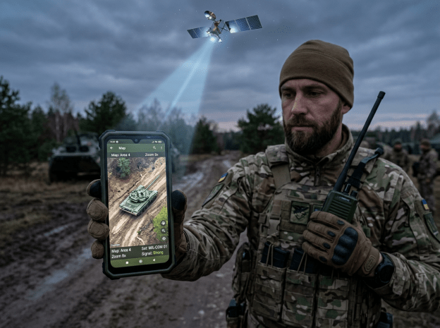
The Ukrainian military’ is using commercial satellite imagery that goes directly to a soldier to guide real-time battle decisions….The same satellites used to monitor illegal fishing and update Google Maps have found a new and deadly application. The technology is a trans-Atlantic collaboration between Colorado-based Vantor, Dutch geospatial intelligence company Bravo1Alpha, U.S.-based Persistent Systems and Ukrainian defense firm Burevii. Vantor’s push into defense helped it reach $900 million in annual recurring revenue in 2025… Vantor’s images go directly from the satellite to the soldier’s tablet, phone or laptop in as little as 15 minutes, bypassing a centralized review in Kyiv that has tended to slow down the flow of intelligence to the front line by hours or days

Excerpt from Heather Somerville, Real-Time Satellite Intelligence Is Making Ukraine’s Drone Strikes Deadlier Than Ever, June 4, 2026

The Billionaires Who Conquer the World One Country at a Time

Elon Musk is so popular in this farming region of Brazil that his face is plastered in stores alongside herds of cows, and local magazines depict him as a superhero. The billionaire’s appeal is simple: His satellite company Starlink has connected Brazil’s vast rural and jungle expanses to the internet.  “We were all rooting for Starlink to come to Brazil…we knew what a big change it would make,” said Arthur Cursino, a ginger farmer here who once had to climb a tree to get a cellphone signal and now, thanks to Starlink, runs one of Brazil’s most popular YouTube channels on farming.

But Starlink’s rapid expansion has come as officials in the administration of leftist President Luiz Inácio Lula da Silva have raised concerns about Musk’s growing influence over the country. After getting regulatory approval two years ago, Starlink eclipsed competitors in May 2024 to become the country’s biggest satellite internet provider.  Musk, a billionaire whose companies include social-media platform X and electric-car maker Tesla, has courted right-wing leaders around the world, including da Silva’s predecessor and rival, Jair Bolsonaro. Musk threw his support behind the candidacy of former President Donald Trump.

The regions where Starlink has become popular—Brazil’s agricultural heartland and the Amazon rainforest—are Bolsonaro strongholds where da Silva faces deep political opposition. Now, Brazil’s federal audit court is investigating Starlink’s use by public authorities in the country, threatening to place restrictions on the service. Anatel, the telecoms regulator, has opened a separate inquiry into Starlink, saying that its rapid growth in subscribers of more than 20% a month could crowd out new players.

Excerpt from Samantha Pearson, Brazil Sees Elon Musk’s Starlink as a Political Threat, July 26, 2024

How to Track 1,000 People at the Same Time

DARPA is striving to help the military keep track of up to 1,000 targets on earth through the development of new satellite software–a program called ‘Oversight.’

From the DARPA website: DARPA, the U.S. Space Force, and the Space Development Agency (SDA) are developing new satellite constellations to increase the tactical capabilities of U.S. space systems…’Oversight’ seeks software solutions to enable autonomous constant custody, or knowledge of target location within accuracies necessary for mission needs, of up to 1,000 targets from space assets through management of available satellite hardware resources. The project aims to support both peacetime and wartime monitoring of high value targets in contested environments where resources and targets may be highly dynamic.

Current practices require human operators for exquisite satellite solutions. This arrangement does not scale well for the numbers of targets that Oversight is considering. Reliance on individual ground station operators significantly increases latency and minimizes tactical utility of satellite sensor data. Oversight will develop the autonomy necessary to track targets with the operator overseeing at an aggregate level. It will also leverage existing and/or state-of-the-art networks to provide collaboration between satellite and ground resources.