Tag Archives: climate change drought

Mapping the Impossible: Extreme Weather Events

The heatwave that struck parts of North America’s Pacific coast in 2021 propelled temperatures in Lytton, a village in British Columbia, to 49.6°C—4.6° higher than the previous record. On the fourth day of this torment the place erupted in flames and was almost completely destroyed. These events were so out of the ordinary that, in a press conference held some weeks later by climate modelers, they struggled to explain how circumstances had conjured them.

Climatologists reckon the North American heatwave of 2021 was one of the most extreme deviations from meteorological norms ever recorded, anywhere. But others have come close. As the world gets hotter, phenomena once considered rare are becoming common and others, believed impossible, are happening.

This shift in weather patterns has inspired modelers to pay more attention to the tails of the frequency distributions of meteorological possibility which their models generate (see chart), in search of such unprecedented extremes. One recent exercise, led by Erich Fischer at eth Zurich, a technology university in Switzerland, shows how the heatwave that destroyed Lytton could have been foreseen with data available at the time….The approach Dr Fischer used is one of several developed recently. Another, from Britain’s Met Office, is UNSEEN  (Unprecedented Simulation of Extremes with Ensembles)…Researchers in the UK are looking at another sort of extreme event—the risk of “wind droughts” which would wipe out a lot of the country’s wind-turbine-base electricity supply. It would be ironic indeed if Britain’s huge effort to combat climate change in this way were, itself, to fall victim to a changing climate.

The Paris Olympics, to be held in 2024, will take place during that city’s hottest weeks. A group of meteorologists from various French research institutes therefore wondered just how bad a heatwave manifesting itself then might be. Using yet another approach, they found a chance of temperatures being more than 4°C higher than they were during a catastrophic heatwave in 2003, in which tens of thousands died. Since that happened, France has built a “heat plan” which includes an early-warning system and provisions for opening cool spaces if needed.

Excerpts from How to predict record-shattering weather events, Economist, Feb. 11, 2023

How Forests Create Clouds and Cool the Earth

Tropical forests have a crucial role in cooling Earth’s surface by extracting carbon dioxide from the air. But only two-thirds of their cooling power comes from their ability to suck in CO2 and store it. The other one-third comes from their ability to create clouds, humidify the air and release cooling chemicals. This is a larger contribution than expected for these ‘biophysical effects’ says Bronson Griscom, a forest climate scientist.

The analysis, published in Frontiers in Forests and Global Change in March 2022, could enable scientists to improve their climate models, while helping governments to devise better conservation and climate strategies. The findings underscore growing concerns about rampant deforestation across the tropics. Scientists warn that one-third of the world’s tropical forests have been mown down in the past few centuries, and another one-third has been degraded by logging and development. This, when combined with climate change, could transform vast swathes of forest into grasslands

Trees in the tropics provide shade, but they also act as giant humidifiers by pulling water from the ground and emitting it from their leaves, which helps to cool the surrounding area in a way similar to sweating, Griscom says. “If you go into a forest, it immediately is a considerably cooler environment,” he says.

This transpiration, in turn, creates the right conditions for clouds, which like snow and ice in the Arctic, can reflect sunlight higher into the atmosphere and further cool the surroundings. Trees also release organic compounds — for example, pine-scented terpenes — that react with other chemicals in the atmosphere to sometimes create a net cooling effect… When they considered only the biophysical effects, the researchers found that the world’s forests collectively cool the surface of the planet by around 0.5 °C.

Threats to tropical rainforests are dangerous not only for the global climate, but also for communities that neighbour the forests, Lawrence says. She and her colleagues found that the cooling caused by biophysical effects was especially significant locally. Having a rainforest nearby can help to protect an area’s agriculture and cities from heatwaves, Lawrence says. “Every tenth of a degree matters in limiting extreme weather. And where you have forests, the extremes are minimized.”

Excerpts from Freda Kreier, Tropical forests have big climate benefits beyond carbon storage, Nature, 

Planting Trees Can be Bad for the Planet

Some scientists argue that deforestation is not always harmful for the planet. Christopher A. Williams, a professor at Clark University’s Graduate School of Geography (Worcester, Massachusetts), says that instead of warming up the Earth, deforestation can actually cool it down. (See Climate impacts of U.S. forest loss span net warming to net cooling, Feb. 2021) But some experts are concerned that Williams’ work is likely to be misconstrued as permission to continue deforesting, which is not his intention.

It’s widely accepted that our existing forests are vital carbon sinks, and the best course of action is to stop deforestation, while rewilding and reforesting areas already lost. Deforestation contributes to climate change, can cause wildfires, desertification, soil erosion and most of all – releases huge amounts of carbon dioxide which causes global warming.

While the above may be true, Williams’ new research argues that there are two factors we are not acknowledging: the significance of location and something known as ‘the albedo effect’. Put simply, ‘the albedo effect’ is the process in which forests retain heat. Forests tend to be darker than other surfaces, which means they absorb more sunlight and hold onto heat, explains Williams. As a result, some scientists believe that deforestation gets rid of unwanted heat which is contributing to global warming.

“We found that in some parts of the country like the Intermountain West, more forest actually leads to a hotter planet when we consider the full climate impacts from both carbon and albedo effects,” says Professor Williams. He adds that it is important to consider the albedo effect of forests alongside their well-known carbon storage when aiming to cool the planet.

The team discovered that for approximately one quarter of the US, forest loss causes a persistent net cooling because the albedo effect outweighs the carbon effect.  “It is all about putting the right trees in the right place,” explains Williams, “and studies like ours can help identify where the potential for cooling is greatest.”

For instance, loss of forests east of the Mississippi River caused planetary warming, while forest loss in the Intermountain and Rocky Mountain West led to a net cooling. “If we fail to consider both the carbon and the albedo effects, large-scale tree-planting initiatives, such as Canada’s 2Billion Trees Initiative and The Nature Conservancy’s Plant a Billion Trees campaign, could end up placing trees in locations that are counterproductive for cooling the climate system,” he says.

Maeve Campbell, DEFORESTATION COULD BE COOLING THE PLANET DOWN, Euronews, SAY SCIENTISTS, Feb. 17,2021

How to Find the True Cost of Water

At current rates of consumption, the demand for water worldwide will be 40% greater than its supply by 2030, according to the UN. Portfolio managers are realizing that physical, reputational and regulatory water risk could hurt their investments, particularly in thirsty industries such as food, mining, textiles and utilities.

One worry is that shocks to supply could drown or dry out a company’s assets. In recent years Coca-Cola has been forced to close plants in India because of drought. In 2019 floods in America’s Midwest caused disruptions at the facilities of two food giants, Cargill and Tyson Foods. A survey by CDP, a non-profit firm, found that 783 big listed companies had faced a total of $40bn of water-related losses in 2018.

Another concern is that the price a company pays for water could rocket. The market price of water does not reflect the environmental and social costs of using it. Government subsidies also mean that companies often do not pay for its true cost. As aquifers are depleted, though, subsidies could become more costly and unpopular, forcing governments to retract them. S&P Global Trucost, a data provider, reckons that if Fortune 500 companies paid the true cost of water, based on estimates of scarcity, rather than current prices, their profit margins would shrink by a tenth. Margins for food, drink and tobacco firms would fall by three-quarters.

Disclosures of water risk are even patchier than those of greenhouse-gas emissions…Established names like Bloomberg and S&P Global are plugging the gap, as are startups. The result is that investors can approach management armed with data rather than questions. “We are getting rid of the black box that companies hide in.” 

Ceres, a non-profit firm, scores businesses on everything from direct water management to risks in the supply chain. Those seeking more detail can use visual tools, such as Bloomberg’s “maps” function, which plots a company’s facilities over a heat map based on water stress. (California is the same color as swathes of sub-Saharan Africa; far-eastern Russia looks a lot like western Europe.) Firms like Aquantix go further, and try to predict the financial cost of water risk.

The accuracy of such forecasts is not yet proven. For Andrew Mason of Aberdeen Standard Investments, though, they are still useful. They show companies that investors care about water risk and encourage them to share data. “This is where carbon was ten or 15 years ago,” he says.

Excerpt from An expanding pool: Investors start to pay attention to water risk, Economist, Jan. 9, 2021

How to Kill One Million Fish: Murray-Darling

But it took a viral video posted on 8 January 2019 to drive home the ecological catastrophe that was unfolding in the Murray-Darling river system in Australia. In the footage, Rob McBride and Dick Arnold, identified as local residents, stand knee-deep among floating fish carcasses in the Darling River, near the town of Menindee. They scoff at authorities’ claims that the fish die-off is a result of the drought. Holding up an enormous, dead Murray cod, a freshwater predator he says is 100 years old, McBride says: “This has nothing to do with drought, this is a manmade disaster.” Arnold, sputtering with rage, adds: “You have to be bloody disgusted with yourselves, you politicians and cotton growers.”

Scientists say McBride probably overestimated the age of the fish. But they agree that the massive die-off was not the result of drought. “It’s about taking too much water upstream [to irrigate farms] so there is not enough for downstream users and the fish,” says Quentin Grafton, an economist specializing in water issues at Australian National University (ANU) in Canberra. The Australia Institute, a Canberra-based think tank, blamed “policy failure and mismanagement” in a 19 January 2019 report, but called drought a catalyst.

Excessive water use has left river flows too low to flush nutrients from farm runoff through the system, leading to large algal blooms, researchers say. A cold snap then killed the blooms, and bacteria feeding on the dead algae sucked oxygen out of the water,   This wasn’t supposed to happen. In 2012, the national government adopted the Murray-Darling Basin Plan, touted as a “historic” deal to ensure that enough water remained in the rivers to keep the ecosystem healthy even after farmers and households took their share.

In 2008, the federal government created the Murray-Darling Basin Authority to wrestle with the problem. In 2010, a study commissioned by the authority concluded that farmers and consumers would have to cut their use of river water by at least 3000 but preferably by 7600 gigaliters annually to ensure the health of the ecosystem. Farmers, who saw their livelihoods threatened, tossed the report into bonfires.  The final plan, adopted as national law in 2012, called for returning just 2750 gigaliters to the rivers, in part by buying water rights back from users. “It was a political compromise that has never been scientifically reviewed,” Williams says, adding that “climate change was never considered in the plan, which was a dreadful oversight.”..

Grafton says there are also suspicions of widespread water theft; up to 75% of the water taken by irrigators in the northern part of the system is not metered. Farmers are also now recapturing the runoff from irrigated fields that used to flow back into streams, and are increasing their use of ground water, leaving even less water in the system, says Mike Young, an environmental policy specialist at the University of Adelaide in Australia.

In February 2018, such issues prompted a group of 12 academics, including scientists and policy experts, to issue the Murray-Darling Declaration. It called for independent economic and scientific audits of completed and planned water recovery schemes to determine their effects on stream flows. The group, which included Williams and Grafton, also urged the creation of an independent, expert body to provide advice on basin water management. Young, who wasn’t on the declaration, wants to go further and give that body the power to manage the basin’s water, the way central banks manage a country’s money supply, using stream levels to determine weekly irrigation allocations and to set minimum flow levels for every river.

Excerpts from Dennis Normile, Massive fish die-off sparks outcry in Australia, Science, Jan. 22, 2019.

The Desert at the Heart of the Amazon Rainforest

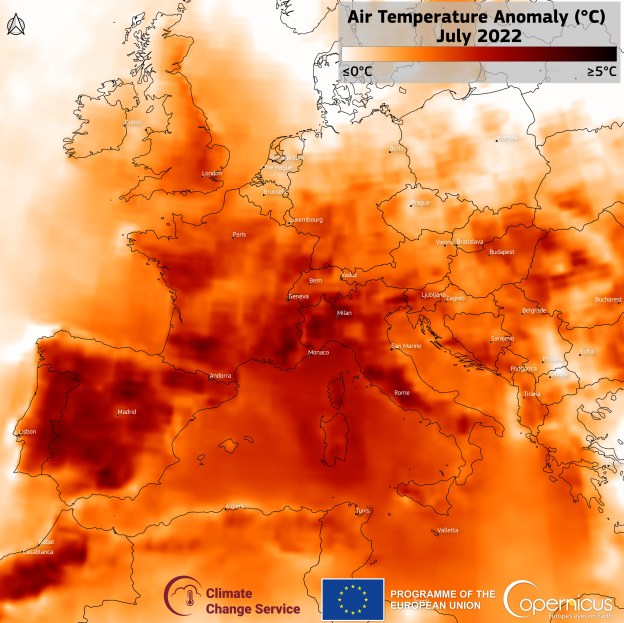
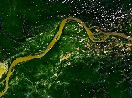
An area of the Amazon rainforest twice the size of California continues to suffer from the effects of a megadrought that began in 2005, finds a new NASA-led study. These results, together with observed recurrences of droughts every few years and associated damage to the forests in southern and western Amazonia in the past decade, suggest these rainforests may be showing the first signs of potential large-scale degradation due to climate change.

An international research team led by Sassan Saatchi of NASA’s Jet Propulsion Laboratory, Pasadena, Calif., analyzed more than a decade of satellite microwave radar data collected between 2000 and 2009 over Amazonia. The observations included measurements of rainfall from NASA’s Tropical Rainfall Measuring Mission and measurements of the moisture content and structure of the forest canopy (top layer) from the Seawinds scatterometer on NASA’s QuikScat spacecraft.

The scientists found that during the summer of 2005, more than 270,000 square miles (700,000 square kilometers, or 70 million hectares) of pristine, old-growth forest in southwestern Amazonia experienced an extensive, severe drought. This megadrought caused widespread changes to the forest canopy that were detectable by satellite. The changes suggest dieback of branches and tree falls, especially among the older, larger, more vulnerable canopy trees that blanket the forest.

While rainfall levels gradually recovered in subsequent years, the damage to the forest canopy persisted all the way to the next major drought, which began in 2010. About half the forest affected by the 2005 drought – an area the size of California – did not recover by the time QuikScat stopped gathering global data in November 2009 and before the start of a more extensive drought in 2010.

“The biggest surprise for us was that the effects appeared to persist for years after the 2005 drought,” said study co-author Yadvinder Malhi of the University of Oxford, United Kingdom. “We had expected the forest canopy to bounce back after a year with a new flush of leaf growth, but the damage appeared to persist right up to the subsequent drought in 2010.”

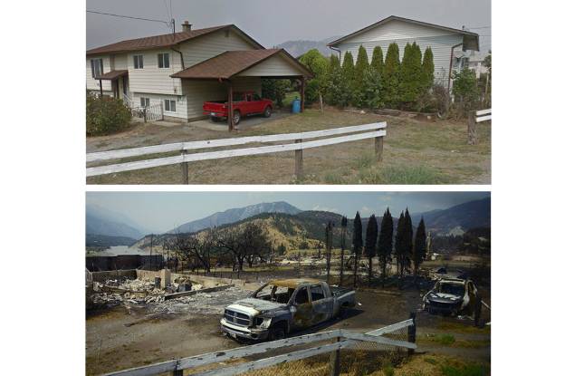
Recent Amazonian droughts have drawn attention to the vulnerability of tropical forests to climate change. Satellite and ground data have shown an increase in wildfires during drought years and tree die-offs following severe droughts. Until now, there had been no satellite-based assessment of the multi-year impacts of these droughts across all of Amazonia. Large-scale droughts can lead to sustained releases of carbon dioxide from decaying wood, affecting ecosystems and Earth’s carbon cycle.

The researchers attribute the 2005 Amazonian drought to the long-term warming of tropical Atlantic sea surface temperatures. “In effect, the same climate phenomenon that helped form hurricanes Katrina and Rita along U.S. southern coasts in 2005 also likely caused the severe drought in southwest Amazonia,” Saatchi said. “An extreme climate event caused the drought, which subsequently damaged the Amazonian trees.”

Saatchi said such megadroughts can have long-lasting effects on rainforest ecosystems. “Our results suggest that if droughts continue at five- to 10-year intervals or increase in frequency due to climate change, large areas of the Amazon forest are likely to be exposed to persistent effects of droughts and corresponding slow forest recovery,” he said. “This may alter the structure and function of Amazonian rainforest ecosystems.”

The team found that the area affected by the 2005 drought was much larger than scientists had previously predicted. About 30 percent (656,370 square miles, or 1.7 million square kilometers) of the Amazon basin’s total current forest area was affected, with more than five percent of the forest experiencing severe drought conditions. The 2010 drought affected nearly half of the entire Amazon forest, with nearly a fifth of it experiencing severe drought. More than 231,660 square miles (600,000 square kilometers) of the area affected by the 2005 drought were also affected by the 2010 drought. This “double whammy” by successive droughts suggests a potentially long-lasting and widespread effect on forests in southern and western Amazonia.

The drought rate in Amazonia during the past decade is unprecedented over the past century. In addition to the two major droughts in 2005 and 2010, the area has experienced several localized mini-droughts in recent years. Observations from ground stations show that rainfall over the southern Amazon rainforest declined by almost 3.2 percent per year in the period from 1970 to 1998. Climate analyses for the period from 1995 to 2005 show a steady decline in water availability for plants in the region. Together, these data suggest a decade of moderate water stress led up to the 2005 drought, helping trigger the large-scale forest damage seen following the 2005 drought…

Results of the study were published recently in the Proceedings of the National Academy of Sciences. Other participating institutions included UCLA; University of Oxford, United Kingdom; University of Exeter, Devon, United Kingdom; National Institute for Space Research, Sao Jose dos Campos, Sao Paulo, Brazil; Boston University, Mass.; and NASA’s Ames Research Center, Moffett Field, Calif.

Study Finds Severe Climate Jeopardizing Amazon Forest, NASA Press Release, Jan. 17, 2013