Tag Archives: monitoring oceans

God’s Channels: How to Hear Whales and Bomb Explosions

About 1 kilometer under the sea lies a sound tunnel that carries the cries of whales and the clamor of submarines across great distances. Ever since scientists discovered this Sound Fixing and Ranging (SOFAR) channel in the 1940s, they’ve suspected a similar conduit exists in the atmosphere. But few have bothered to look for it, aside from one top-secret Cold War operation.

Today by listening to distant rocket launches with solar-powered balloons, researchers say they have finally detected hints of an aerial sound channel, although it does not seem to function as simply or reliably as the ocean SOFAR. If confirmed, the atmospheric SOFAR may pave the way for a network of aerial receivers that could help researchers detect remote explosions from volcanoes, bombs, and other sources that emit infrasound—acoustic waves below the frequency of human hearing.

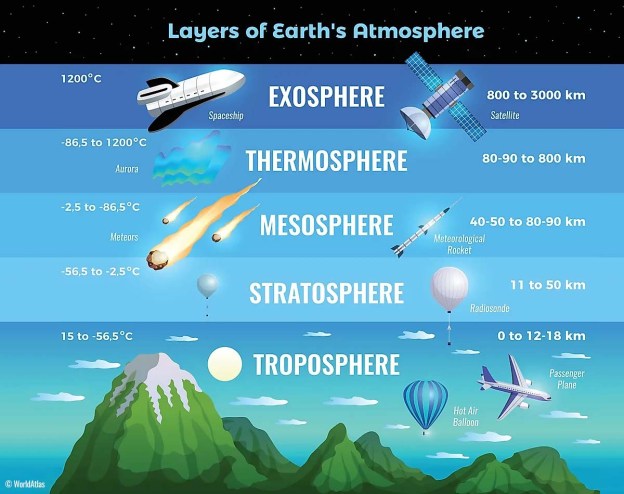
After geophysicist Maurice Ewing discovered the SOFAR channel in 1944, he set out to find an analogous layer in the sky. At an altitude of between 10 and 20 kilometers is the tropopause, the boundary between the troposphere, the lowest layer of the atmosphere (where weather occurs), and the stratosphere. Like the marine SOFAR, the tropopause represents a cold region, where sound waves should travel slower and farther. An acoustic waveguide in the atmosphere, Ewing reasoned, would allow the U.S. Air Force to listen for nuclear weapon tests detonated by the Soviet Union. He instigated a top-secret experiment, code-named Project Mogul, that sent up hot air balloons equipped with infrasound microphones. The instruments often malfunctioned in the high winds, and in 1947, debris from one balloon crashed just outside of Roswell, New Mexico; that crash sparked one of the most famous UFO conspiracy theories in history. Soon after, the military disbanded the project. But the mission wasn’t declassified for nearly 50 years…

[Today] researchers plan to listen to launches of rockets with multiple solar-powered balloons staggered at different altitudes to figure out where the channel’s effects are strongest. They also plan to test the range of the signals and investigate the mysterious background noise. Understanding how the channel functions could help lay the groundwork for a future aerial infrasound network, which would monitor Earth constantly for major explosions and eruptions.

Excerpts from Zack Savisky, Balloon Detects First Signs of a ‘Sound Tunnel’ in the Sky, Science, Apr. 27, 2022

How to Exploit the Secrets of the Ocean: DARPA

PARC, A Xerox Company, announced on October 22, 2020,  it has been awarded a contract by the Defense Advanced Research Projects Agency (DARPA) for the next development phase in the Ocean of Things. Initially announced by DARPA in 2017, the Ocean of Things project is deploying small, low-cost floats in the Southern California Bight and Gulf of Mexico to collect data on the environment and human impact. This includes sea surface temperature, sea state, surface activities, and even information on marine life moving through the area.

Xerox Ocean Float is Equipped with Camera, GPS and other sensors. Ocean of Things

“Oceans cover more than 70 percent of the earth’s surface, but we know very little about them,” said Ersin Uzun, vice president and general manager of the Internet of Things team at Xerox. “The floats gather data that we could never track before, enabling persistent maritime situational awareness.” Each solar-powered drifter has approximately 20 onboard sensors, including a camera, GPS, microphone, hydrophone, and accelerometer. The different  sensors can provide data for a broad array of areas including ocean pollution, aquafarming and transportation routes…Among other things, the float needed to be made of environmentally safe materials, be able to survive in harsh maritime conditions for a year or more before safely sinking itself, and use advanced analytic techniques to process and share the data gathered…PARC built 1,500 drifters for the first phase of the project and will deliver up to 10,000 that are more compact and cost-effective for the next phase. 

Excerpt from DARPA Awards PARC Contract to Expand Ocean Knowledge, XEROX Press Release, Oct. 22, 2020

Even the Oceans are not Free: Swarming the Seas

The Ocean of Things of Defence Advanced Research Projects Agency (DARPA) aims to  wire up the high seas with swarms of floating, connected sensors.  Such devices are not in themselves new. There are around 6,000 floating sensors deployed around the world’s oceans, run by navies and research institutes. What is unprecedented is the scale of  DARPA’s ambition. Over the next few years it hopes to deploy 50,000 sensors across 1m square kilometres of sea, an area considerably larger than Texas. The eventual goal—much more distant—is to enable the continuous monitoring and analysis of a significant fraction of the world’s oceans.

Existing “floating instrument packages”, known as floats or drifters, are often custom-built, and usually contain the highest-quality instruments available. They therefore tend to be expensive, and are bought only in small numbers. A typical existing float, designed for scientific research, is the Argo. It costs around $20,000, and can measure water temperature and salinity.  The Ocean of Things takes the opposite approach. The aim is to cram as many cheap, off-the-shelf components as possible into a single low-cost package. Current float prototypes cost around $750…That would allow tens of thousands to be deployed without breaking the bank. Large numbers are crucial for coverage. They also help compensate for inaccuracies in individual instruments.

The project’s researchers are evaluating three designs from different manufacturers, ranging in size from about six to 18 litres. One, proposed by Xerox’s Palo Alto Research Centre, is made of glass, like a traditional Japanese fishing float. A second, from a firm called Areté Associates, has an aluminium shell, and uses wood for buoyancy. Both models feature solar panels. The third, made by a company called Numurus, is made of lacquered cardboard, and relies entirely on its batteries. All three are designed to last for a year or so and are made to be as environmentally friendly as possible, with minimal use of plastics. That is important because, at the end of their mission, the floats are designed to scuttle themselves

With 361m square kilometres of ocean on the planet, a true Ocean of Things, monitoring everything on and under the water, would require about 18m floats.

Excerpts from Big Wet Data: The Ocean of Things, Economist, Mar. 14, 2020

A Brand New World: Mapping the Ocean Floor

Mapping of the ocean floor may expand under an order signed by President Donald Trump on in  November, 2019 to create a federal plan to explore U.S. coastal waters. The announcement…comes amid growing international interest in charting the sea floor as unmanned aquatic drones and other new technologies promise to make the work cheaper and faster. The maps, also created by ship-towed sonar arrays, are crucial to understanding basic ocean dynamics, finding biological hot spots, and surveying mineral, oil, and gas deposits.

But much of the ocean floor remains unmapped; an international campaign called Seabed 2030 aims to map all of it in detail by 2030. Such maps cover just 40% of the 11.6 million square kilometers in the U.S. exclusive economic zone, which extends 320 kilometers from the coasts of all U.S. states and territories—an area larger than the total U.S. land mass. Today, those maps are a hodgepodge drawn from government, industry, and academic research, says Vicki Ferrini, a marine geophysicist at Columbia University’s Lamont-Doherty Earth Observatory in Palisades, New York. The federal plan, she says, could be a “game changer.”

Excerpts from  United States to Survey Nearby Sea Floor, Science, Nov. 29, 2019, at 6469

5,000 Eyes in the Sky: environmental monitoring

The most advanced satellite to ever launch from Africa will soon be patrolling South Africa’s coastal waters to crack down on oil spills and illegal dumping.  Data from another satellite, this one collecting images from the Texas portion of a sprawling oil and gas region known as the Permian Basin, recently delivered shocking news: Operators there are burning off nearly twice as much natural gas as they’ve been reporting to state officials.

With some 5,000 satellites now orbiting our planet on any given day…. They will help create a constantly innovating industry that will revolutionize environmental monitoring of our planet and hold polluters accountable…

A recent study by Environmental Defense Fund focused on natural gas flares from the wells in the Permian Basin, located in Western Texas and southeastern New Mexico. Our analysis proved that the region’s pollution problem was much larger than companies had revealed.  A second study about offshore gas flaring in the Gulf of Mexico, published by a group of scientists in the Geophysical Research Letters, showed that operators there burn off a whopping 40% of the natural gas they produce.

Soon a new satellite will be launching that is specifically designed not just to locate, but accurately measure methane emissions from human-made sources, starting with the global oil and gas industry.  MethaneSAT, a new EDF affiliate unveiled in 2018, will launch a future where sensors in space will find and measure pollution that today goes undetected. This compact orbital platform will map and quantify methane emissions from oil and gas operations almost anywhere on the planet at least weekly.

Excerpts from Mark Brownstein, These pollution-spotting satellites are just a taste of what’s to come, EDF, Apr. 4, 2019

Underwater Robots against Pollution

Subcultron is a swarm of at least 120 self-directing, underwater robots being developed by scientists in six countries to monitor Venice’s polluted waterways and transmit environmental data to government officials.The robots, shaped like fish, mussels, and lily pads to mimic the species’ hydrodynamics, carry sensors to monitor water conditions like temperature and chemical composition…The swarm communicates via the Internet-capable lily pads…
The robots use lithium ion batteries and solar cells for power. (Yes, enough sunlight gets through.)Some of the robots carry cameras. Others have electrodes that allow them to “see” by measuring objects crossing the electric fields they generate.Using wireless signals, human monitors can take over from the swarm’s AI software if something goes wrong. The European Commission has granted the project €4 million ($4.4 million).
Thomas Schmickl, the inventor, …..plans to build robot swarms that can monitor the oceans or even faraway moons that have water.

Excerpts from Innovation Subcultron, Bloomberg Business Week, Jan. 28, 2016